Venice: The Lagoon Forest
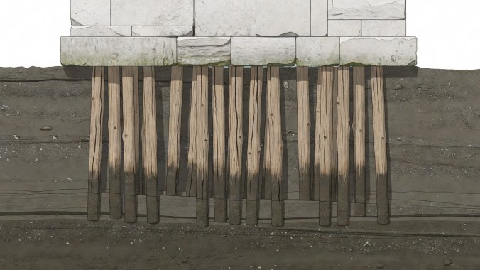
Beneath the soaring bell tower of St. Mark's and the Gothic tracery of the Doge's Palace sits an inverted urban forest: over ten million tree trunks driven upside down into salt silt to sustain an empire made of stone.
The Geotechnical Anatomy of the Lagoon
The Venetian archipelago consists of 118 distinct islands separated by 177 canals in an expansive, shallow tidal lagoon of roughly 550 square kilometers. The surface soil is composed of unconsolidated mud and soft silty clays termed melma, utterly incapable of supporting heavy masonry structures.
However, between 3.5 and 7.5 meters below this waterlogged slime lies a dense, compact geological stratum called caranto—an overconsolidated Pleistocene clay mixture that was desiccated and compressed during the last glacial maximum. The foundational genius of Venetian carpenters was to drive timber trunks through the soft silt until the tips wedged firmly into this rock-like caranto.
Tree Selection & Driving Sequence
Venetians harvested millions of alder, oak, larch, and pine trees from the Cadore forests in the Alps, floating them down the Brenta and Piave rivers. Timber piles (typically 2 to 4 meters long, 20 cm in diameter) were hammered in tight radial clusters using human-powered drop hammers (battipalo).
The Zatterone Timber Platform
Once driven until refusal, pile tops were cut off flat beneath the low-tide waterline. A double layer of thick larch and oak timber beams—the zatterone—was pinned atop the piles, acting as a rigid raft to equalize building loads.
Istrian Stone Plinth (Pietra d'Istria)
Above the timber zatterone, masons laid courses of impermeable Istrian limestone right at the intertidal zone. This prevented capillary action from drawing saline water into upper brickwork, halting efflorescence and freeze-thaw fractures.
The Acqua Alta Phenomenon and Astronomical Resonance
High tide flooding, known as Acqua Alta, occurs primarily between October and March. It is generated by a convergence of three atmospheric and oceanic forces: the astronomical tide cycle (spring tides), low atmospheric pressure over northern Italy, and persistent southerly Sirocco winds blowing up the narrow Adriatic trough, pushing seawater directly into the lagoon mouths.
| Flood Level (Tide Gauge) | City Area Submerged | Primary Impact Zone | Standard Defense Protocol |
|---|---|---|---|
| +80 cm to +99 cm | 1.5% | Piazza San Marco lowest flagstones | Elevated wooden pedestrian catwalks (passerelle) |
| +100 cm to +109 cm | 5.1% | Piazza San Marco and Rialto quays | Sirens sound tone warning; shop flood-boards sealed |
| +110 cm to +139 cm | 12% to 59% | Pervasive street & ground-floor flooding | MOSE mobile sea gates activated at lagoon inlets |
| +140 cm and above (Exceptional) | Over 60% | Catastrophic whole-lagoon inundation | Complete enclosure of all three Adriatic inlets |
MOSE: The Mechanical Shield
Since 2020, Venice has been shielded by MOSE (Modulo Sperimentale Elettromeccanico). Engineered across the Lido, Malamocco, and Chioggia inlets, the barrier consists of 78 independent steel gate boxes anchored in 36 huge concrete seabed caissons.
When an astronomical tide surge exceeding 110 cm is predicted, compressed air is pumped into the water-filled gates. Displacing the water, buoyancy swings each gate upward from its seabed trench, forming a wall against the sea. Once the high tide recedes, water is pumped back in, and the gates submerge out of sight, preserving the lagoon's aesthetic horizon.